
Plainfield Township ZIP Code Coverage
The official Kent County Street Directory is the strongest local crosswalk located for Plainfield Township. Its rows use address, range, odd/even, street, political jurisdiction, and school district columns. The four ZIP values below are the postal-locality combinations found in its Plainfield Township examples. They are useful search terms, not a claim that each ZIP lies entirely inside the township or reaches every township address.
| ZIP | Areas Covered | Post Office | Notes |
|---|---|---|---|
| 49306 | Belmont-address rows, including Gold Dust Street and Goldfinch Drive examples | Belmont postal locality | Mailing city is not the legal township name. |
| 49321 | Comstock Park-address rows, including 9 Mile Road examples | Comstock Park postal locality | Read range and school-district fields together. |
| 49341 | Rockford-address rows, including Black Forest Drive and north/east examples | Rockford postal locality | Rockford mail identity can coexist with Plainfield Township jurisdiction. |
| 49525 | Grand Rapids-address rows, including Boyd and Bird examples in the Northview area | Grand Rapids postal locality | It does not mean the address is in the City of Grand Rapids. |
Do not add 49544 to a Plainfield Township search list. The county PDF includes that ZIP in other township rows, including Alpine, but the research did not locate it as Plainfield Township coverage. That negative finding matters because a plausible nearby ZIP can create a false match.
Plainfield Township ZIP Code Fields
A ZIP code directory needs more than a ZIP column. The county street-directory PDF connects a street range to political jurisdiction and a school district. That makes it possible to preserve the labels that can change within the same road. Boyd Avenue and Boyd Court appear with Grand Rapids 49525 and Northview. Black Forest Drive appears with Rockford 49341 and Rockford. Gold Dust Street and Goldfinch Drive show Belmont 49306 and Rockford. On 9 Mile Road, both postal and school labels can depend on the range.
| County street-directory field | Use in a ZIP code search |
|---|---|
| Address and range | Match the house number or range before assigning a locality. |
| Odd/even | Test which side of a road the range applies to. |
| Street | Keep the local road name with its direction and descriptor variants. |
| Political jurisdiction | Confirm Plainfield Township rather than relying on the postal city. |
| School district | Retain another local geography that may vary along a road. |
Save the street-directory page or row used. A ZIP code is delivery geography; the jurisdiction column is the local government check. The parcel or GIS result supplies a separate property check.
Plainfield Township ZIP Code Search Route
To search a location within one ZIP, begin with the address, the original postal string, and the county street-directory row. A ZIP-only search can pull in nearby places outside the township. Searching only Plainfield, Michigan can miss a valid Belmont or Rockford mailing string. The useful sequence compares the local directory, postal normalization, and property record rather than expecting one database to answer all three questions.
- Write down the address exactly as received, including any apartment or suite separately from the base street address.
- Use the county street directory to find the matching street range, ZIP, political jurisdiction, and school-district label.
- Check the address through USPS ZIP Lookup for current delivery formatting and any required unit information.
- Search the address or parcel in Kent Property Search, then retain the parcel identifier with the postal and jurisdiction labels.
- Move to the Plainfield Township street directory when a ZIP result has narrowed the question to a street-by-street record trail.
Note: A current USPS match checks an address format, not occupancy, ownership, or continuity with an older directory entry.
Plainfield Township ZIP Code USPS Fields
USPS ZIP Lookup supplies the postal part of the workflow. Its address mode, city/state mode, and cities-by-ZIP mode have different inputs. The tool warns that a result does not verify that a person or business is at an address. When several units share a base address, a unit may be needed before the match is useful.
| Field label | Mode | Required | Options or format notes |
|---|---|---|---|
| Company | Address lookup | No | Optional identifying line. |
| Street address | Address lookup | Yes | Use standardized address formatting where possible. |
| Apartment, suite, or other | Address lookup | No | May resolve a multiple-match result. |
| City and state | Address lookup or city/state lookup | Yes for city/state mode | Use the source's postal locality, not a guessed jurisdiction label. |
| ZIP | Address lookup or cities-by-ZIP | Optional in address mode; required for cities-by-ZIP | Use to check postal associations, not property boundaries. |
USPS is the address-format control. The Kent PDF is the local jurisdiction control. Neither is a complete list of people connected to the address.
Plainfield Township ZIP Code Property Search
Kent Property Search has an address and municipality workflow, but the inspected interface does not have a ZIP field. That is an important local limit. Use the county PDF and USPS to establish the postal context first, then search by street number or range, street name, and the 26 - PLAINFIELD TOWNSHIP municipality choice. The system also offers active and inactive parcel choices and requires a CAPTCHA.
This Kent Property Search capture shows the address-oriented interface. It is assigned to the ZIP code directory because it explains why a ZIP-first query must be translated into an address or parcel search.
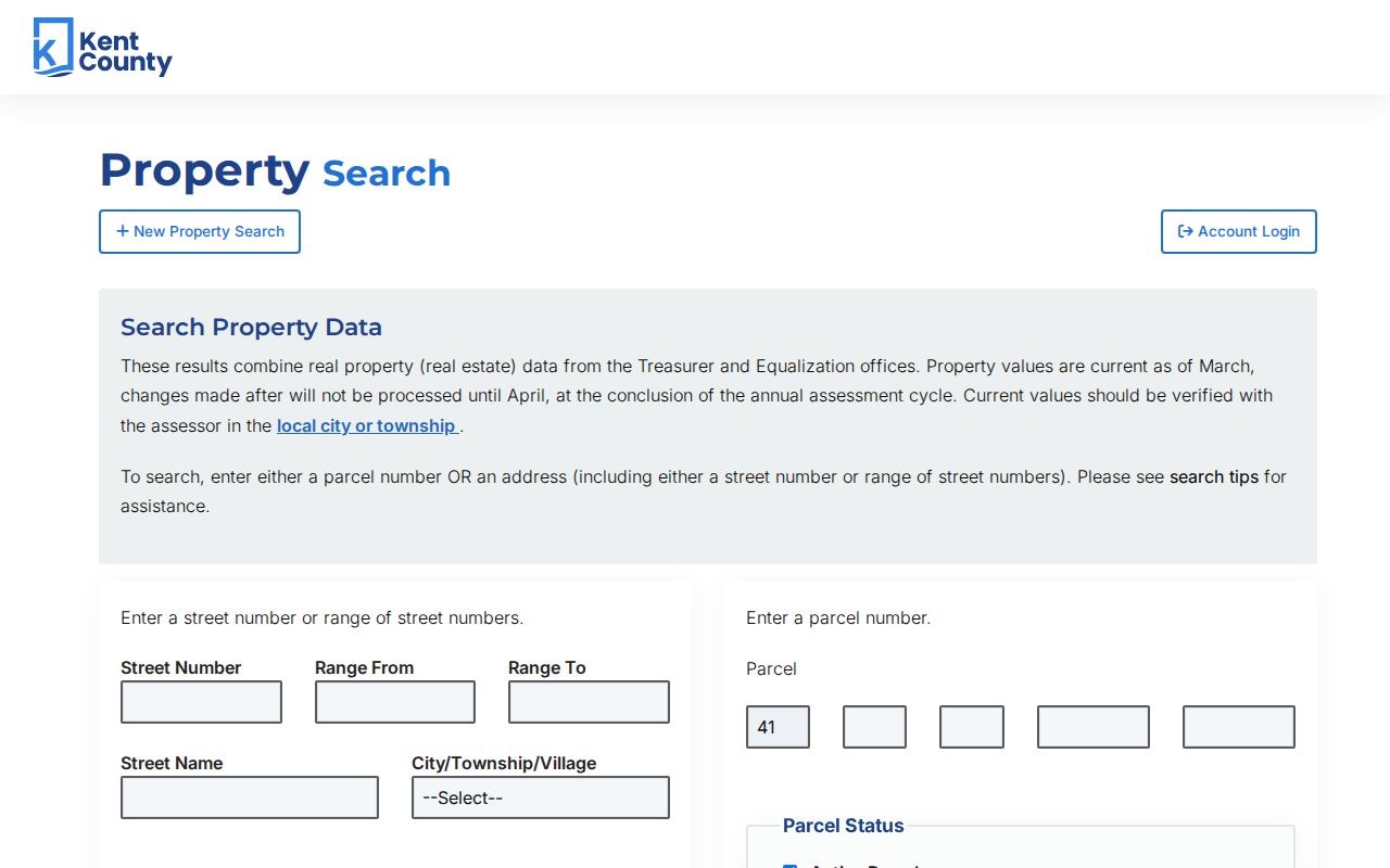
The portal says its values are current as of March, with changes processed after that point appearing in the annual assessment cycle. Record the assessment year and parcel number with every result.
The parcel form is another useful fallback after an address result supplies the identifier. Kent formats that entry with a fixed 41 prefix and four segments of 2, 2, 3, and 3 characters. It uses the same active or inactive parcel choices. That structure is a parcel key, not a ZIP code filter. It can still help reconcile a street-range result with a property record when a postal locality changes between sources.
Plainfield Township ZIP Code Boundaries
ZIP boundaries and Plainfield Township boundaries do not mean the same thing. A mailing city names a post office route or accepted address format. The political jurisdiction identifies the township. A street can move from one postal locality or school district to another by range while remaining in the same township. Keep “Plainfield Township” and the postal city side by side, rather than replacing one with the other.
Boundary check. Searching only a ZIP can include addresses outside Plainfield Township, while searching only the township name can hide a valid Belmont, Rockford, Comstock Park, or Grand Rapids mailing string.
The local property portal has no ZIP filter, and no Plainfield-specific official ZIP-filter portal was located in the research. A ZIP boundary map can be a rough visual aid, but the county street row and parcel result are better controls for an individual address.
Plainfield Township ZIP Code History Tests
Current ZIPs should not be projected backward onto older directory records. An older entry may use a rural route, a village name, or a Grand Rapids regional label before a current ZIP existed. No official source reviewed supplied a Plainfield-specific historical street-renumbering table. Grand Rapids Public Library's 1912 address-change warning applies to many Grand Rapids addresses, not automatically to the township.
When an old and current address disagree, compare the legal description, section or parcel, nearby roads, plat, deed, county map, postal city, and family name. Mark the bridge as tentative until two source types agree. Preserve the publication year, printed postal city, delivery notation, USPS normalization, and jurisdiction. A ZIP code is a delivery clue, not historical proof that two address strings identify the same house.
Grand Rapids Public Library's house-history material adds plats, Sanborn maps, directories, aerials, and appraisal-card leads to that comparison. The research specifically warns that a Grand Rapids appraisal-card series should not be assumed to cover a Plainfield Township property. Ask the local assessor or relevant repository which collection applies before using a city record to interpret a township address.
Note: Keep the original string, every direction or punctuation variant tried, the USPS response, county row, Property Search query, and returned parcel for a reproducible search record.
Plainfield Township ZIP Code Definitions
Postal terms answer different questions, which matters when a Plainfield Township search moves between an old directory, a current parcel, and a delivery tool. The terms below keep the ZIP code directory from overstating what a route or code proves.
- ZIP and ZIP+4
- A ZIP is the basic postal routing code. ZIP+4 adds a more specific delivery segment; neither one proves residency.
- PO-box ZIP
- A postal code used for post-office boxes rather than a geographic household area.
- Unique ZIP
- A code assigned to one large organization or recipient. It is not a township-boundary label.
- Carrier route
- A delivery sequence used by the postal service. It can change and is not a government-jurisdiction line.
The county PDF is a street-range directory, not a list of every address or a ZIP-boundary shapefile. Describe the four values here as examples found in its Plainfield Township rows unless an official source supports a more complete claim.
That wording keeps a useful postal search from becoming a claim about every road, parcel, or household served by a code.